MTB route · Rogatica · Borike marathon
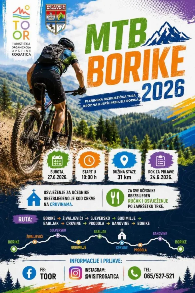
MTB Borike 2026 – 30 km Loop near Rogatica
This Rogatica MTB route is a 30 km loop through the pine forests of the Romanija region, below Devetak mountain, with 565 m of climbing. Guide, map, GPX and ITRS difficulty rating in one place.

Length
30 km
Descent
−565 m
Highest point
~1170 m
Climb
565 m
ITRS score
201

Difficulty (ITRS)
Green route (L1)
Packed dirt and forest roads

Physical effort
Moderately demanding (L2)
565 m of climbing over 30 km
ITRS Route Pie: route difficulty at a glance
The Route Pie shows the route's ITRS rating across four axes: technique, fitness and logistics, wilderness and risks, and exposure. Click the chart to open an explanation of difficulty, demands and the other parameters.
About the route
MTB Borike 2026: an easygoing Rogatica MTB route below Devetak
The MTB Borike 2026 course was organized by the Rogatica Municipality Tourist Organization under the patronage of the Municipality of Rogatica. This 30 km MTB loop runs through the quiet pine forests of the Romanija region, combining sport, nature and the historical heritage of the area.
The Rogatica MTB route at a glance
- Length 30 km, climb 565 m, descent 565 m (loop, rideable in both directions).
- ITRS score 201: technique L1, fitness L2, wilderness L1, exposure L1.
- Surface: packed dirt and forest roads, with a trail that is mostly wider than 100 cm.
- Reception is excellent (100% 4G), and evacuation is possible in under 10 minutes.
- Water sources are less than 7 km apart, so a small 0.5 l bottle is enough.
The route is a great choice for XC and gravel bikes, and for e-bikes thanks to the solid climbing. You only need basic fitness, and the trail is technically simple.
Key sections of the route
01
Pine forests below Devetak
The trail is north of Rogatica, towards Borike and Devetak mountain. It runs through quiet pine forests with solid climbs, and the start and finish are at the same point.
02
Crkvine and the Church of the Nativity of St. John the Baptist
The refreshment stop at Crkvine is one of the most beautiful spots on the route, below the southern slope of Devetak. It is known for the Church of the Nativity of St. John the Baptist, which local tradition says was built as early as the mid-13th century.
03
Finish with lunch and socializing
After the ride, the hosts from the Rogatica Municipality Tourist Organization welcomed participants with lunch and refreshments. Two refreshment stops were provided during the ride.
Don't underestimate the fitness demands
Although the route is technically simple and very safe, its 30 km length and over 500 m of climbing make it moderately demanding in terms of fitness. We recommend at least a basic recreational level of fitness.
MTB Borike route characteristics
Primary activity
Cross-country, gravel, e-MTB
Route type
Loop, rideable in both directions
E-bikes
Excellent for the solid climbing
Reception
Excellent (100% 4G)
Water
Sources less than 7 km apart
Physical demand
Medium (L2)
Surface
Packed dirt, forest roads
Trailforks
Rogatica MTB route map and elevation profile
The interactive map shows the route track and elevation profile. Load the GPX before you set off.
Gear and riding tips
Required
A helmet is mandatory. A small 0.5 l bottle is enough since water sources are frequent, but bring a tire repair kit.
Recommended
An XC, gravel or e-MTB bike. The route suits XC and gravel bikes well, and thanks to the solid climbing it is great for e-bikes too.
Navigation
The forest roads below Devetak are easy to mix up, so load the GPX onto your device before you start.
Pro tip
Check your tires and brakes before the Borike MTB marathon. We do bike service in our workshop by appointment: book a slot.
Frequently asked questions
Where does the MTB Borike route start, and is it a loop?

The trail is north of Rogatica, towards Borike and Devetak mountain. The route is a loop, so you start and finish at the same point, which makes parking easy.
How demanding is the route in terms of fitness?
Moderately demanding (ITRS L2): 30 km and 565 m of climbing. A basic recreational level of fitness is needed.
Is there drinking water on the route?
Yes, water refill points are less than 7 km apart, so a small 0.5 l bottle is enough.
Which bike is best for this route?
XC and gravel bikes, and thanks to the solid climbing the route is great for e-bikes too.
How long is the MTB Borike route?
The route is 30 km long, with 565 m of climbing and 565 m of descent. Estimated riding time is 2.5 to 3.5 hours.
Ready for Borike?
Prep your bike, load the route and browse all MTB routes in Bosnia and Herzegovina, or contact us for advice on gear and service.